Hydro parcels
Hydro parcels represent where beds of water bodies, such as lakes, rivers and sea beds were when the adjoining land was last surveyed. Not all water bodies and their beds have hydro parcels, and not all hydro parcels cover the current physical location of a water body.
Identifying hydro areas
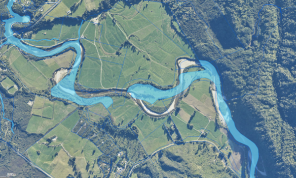
Hydro parcels are represented in light blue in our mapping system, WAMS.The hydro parcel layer is available under the ‘Property’ section in the Layer List on relevant maps.
Hydro parcels sometimes do not align well with actual water areas. You can see this when you overlay a map of hydro parcels with topographical maps or aerial photography.

In this map, the Waitakere River on the West Coast deviates significantly from the blue hydro parcel [2024].
The boundaries of water bodies can move over time because of erosion and accretion, but they are recorded in the cadastral records in the position where they were last surveyed. The cadastral survey may have been completed decades before and may not align with the present location of a waterbody, as shown in more recent aerial photography and topographical maps. A landholder would need to employ a land surveyor to complete a new survey if they wanted the current water boundary to be updated in the cadastral record.
Legal property boundaries for land generally don’t move, but sometimes the legal boundary is defined by the water body beside it, so the boundary in that case can move to follow that water body. Esplanade strips and moveable marginal strips will always move as a water body moves and are not fixed to the property boundary. Other property boundaries may be defined in a static manner and do not move if the water body moves.
Access on hydro parcels
There are no legal public access rights that apply to all hydro parcels. Some are accessible and others are not. Their status can be complicated, and whether or not there is public access cannot always be ascertained. You can get an indication, though, by looking at our mapping system, WAMS.
On the coast, the common marine and coastal area is the part of the hydro area that is below the usual maximum high tide level. The public has a statutory right of access to the common marine and coastal area.
Related information about access to and along water
- Access along rivers, lakes and the coast
- Marginal strips
- Esplanade strips
- Esplanade reserves
- The marine and coastal area
Questions
If you have questions, ask one of our regional field advisors for help.

