Photo by
Permolat Group
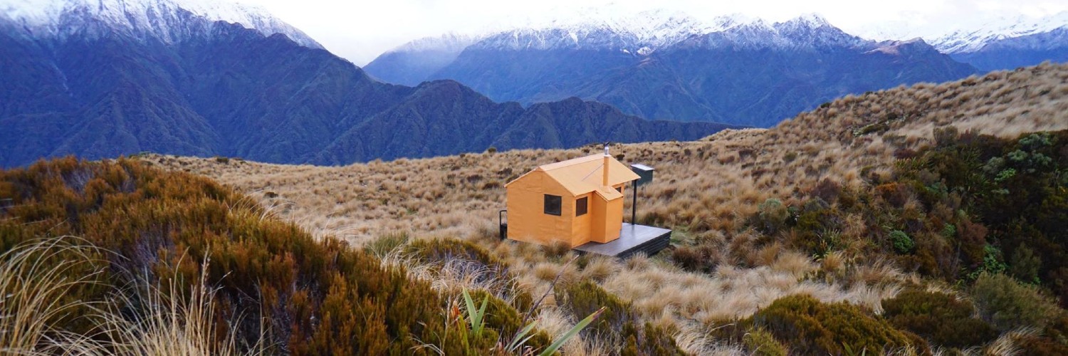
Mt. Brown Hut is a community initiative undertaken by Eddie Newman and Julia Bradshaw of Hokitika. The Hut began its life as Lower Arahura Hut in the valley of the same name, where it spent its first 50 years. When DOC decided to build a new Hut at the site in 2010, Eddie and Julia convinced them to fly the dismantled sections of the old hut out to be reassembled on Mt. Brown.
This approach to the hut is from the Styx Valley and starts at the large unnamed side creek known locally as Mt Brown Creek.
Access up the Styx Valley is along a rough farm trail that turns off the Dorothy Falls Road at a sharp bend 400m north of the Mark Wallace Bridge.
The trail, only useable for a few hundred metres due to flood damage, ends after 1.5 kilometres, and the Styx riverbed is followed for a couple of hundred metres under some large shingle bluffs.
These can usually be waded around at normal flows but could be difficult or impossible if the river is up.
Mt Brown Creek is five minutes upriver from the bluffs, and the Mt Brown track starts 20m up its true left.
The track follows the spur up onto a bush terrace, then climbs up a broad bush face onto the Southern spur of Mt Brown.
The spur flattens at 800m, passing the old Mt Brown Hut site. The old hut was removed by the Department of Conservation in 2006.
The track continues up the spur to around 1000m, crosses a sub-alpine gully, and then resumes its climb up through the scrub towards the tussock line.
Snow poles lead up the last portion of the spur through scattered scrub onto a flat tussock bench with a small tarn just below the hut.
Allow around 4 hours currently from the Styx bluffs to Mt Brown Hut.
Those doing the circuit have a 3-kilometre walk along Dorothy Falls Road between carparks.
Mt Brown Hut is a community initiative that was undertaken by Eddie Newman and Julia Bradshaw.
The Hut began its life as Lower Arahura Hut in the valley of the same name and spent its first 50 years there. It was a standard NZFS 4-bunk S81 design, built in 1962.
When the Department of Conservation decided to build a new hut at the site in 2010, Eddie and Julia convinced it to fly the dismantled sections of the old hut out to be reassembled on Mt Brown.
The project became a total rebuild due to building code and safety requirements. Considerable community input, volunteer labour and donations made it possible for the project to reach fruition.
The Permolat Group contributed financially and with volunteer input, and the hut was opened for public use in November 2010. It was an instant success, debuting in Wilderness Magazine, outdoor calendars, Department of Conservation posters, and the cover of Shelter From The Storm, a book on high-country huts by Rob Brown, Geoff Spearpoint and Shaun Barnett.
The hut is now profiled on local tourist brochures and i-Sites, and the majority of visitors are now foreign tourists or travellers.
In 2017 Eddie and Julia emigrated to Christchurch and delegated oversight of the Hut to the Permolat Group. Hugh van Noorden from the Permolat Trust has kindly taken on the lead role for the project.
Mt Brown Hut has no fixed fee system and is reliant on a koha for its upkeep. Koha means a contribution, not just donate-if-you-feel-like-it. The hut has a small firebox and because there is no good wood supply at 1100m, coal needs to be flown in. Supplies tend to get used up very quickly and when it runs out it is not uncommon for less conscientious types to start hacking into the living alpine scrub around the hut. Contributions also go towards hut maintenance and upkeep of the access tracks. Sadly, the majority of visitors are not donating.
This hut is not DOC funded so don't be a freeloader. Donations are payable to Permolat Trust, Kiwibank, 38-9016-0266330-00. Its Charities Registration No. is CC50626. Please specify that the donation is for Mt Brown so the trust can earmark it for that purpose.
This approach to the hut is from the Styx valley and starts at the large unnamed side-creek known locally as Mt Brown Creek.
Access up the Styx valley is along a rough farm trail that turns off the Dorothy Falls Road at sharp bend 400m north of the Mark Wallace Bridge.

This trail currently has no photos.
This track is part of the Herenga ā Nuku Aotearoa track database. Herenga ā Nuku has maps and advice about public access to the outdoors.
We encourage you to continue gaining the skills and knowledge required for a safe trip. The NZ Mountain Safety Council has lots of free resources and information you can use. You can access them at www.mountainsafety.org.nz.
We recommend trying these online learning tools:
Additionally, check out the range of helpful videos available from the NZ Mountain Safety Council YouTube channel.
