Photo by
johnranta
Te Araroa section: The Hakarimata Track is hilly and arduous but the bush and views are worth it. You can walk the Hakarimata Walkway from either its southern end, near Ngāruawāhia, or northern end, closer to Huntly. There are car parks at both ends of the track.
The track from Parker Road starts on the Kauri Loop Track, which leads up a long flight of steps, then levels out to an open area with views to the north. Take the Kauri Loop Track west of the Lower Lookout to walk on past an old pā site and through bush to the large kauri trees. A few minutes further on, there's the kauri grove bush viewpoint. This loop track takes you through to the Upper Lookout.
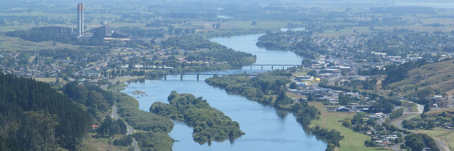
The Hakarimata Walkway starts from the Upper Lookout. Head in a southerly direction for 20 minutes to the southern lookout where there are excellent views south across Hamilton. The Walkway continues along the undulating crest of the Hakarimata Range with occasional views out to the west and east.
Approximately 500m southeast of high point labeled 314 on the map (at km 750.6), there is a rough exit track heading down in an easterly direction past the old quarry to Hakarimata Road on the western banks of the Waikato River. It's obviously used by locals as a shortcut to town, but it is tight in places.
The main ridge track continues southwards to the Hakarimata Trig at 374m high. Walking 200m south of the trig, take the track leading down towards the Mangarata Stream. This track - "the Summit Track" is a tremendous success story, where the local community have adopted it as a community wellbeing tool, and it won't be uncommon to see locals heading up or down the track (often multiple times) in their quest for better health outcomes. Kia kaha!
The track then comes out on Brownlee Avenue, which connects with Hakarimata Road. Follow the road southeast until reaching the Waingaro Road Bridge over the Waipā River. The track officially ends on the eastern bank.
If you are after amenities, continue east across the railway and Great South Road to reach Jesmond Street - the main business road in the small township of Ngāruawāhia.
No dogs allowed.
This is a one-way track but it can be walked as return trips to the summit from either end. The track can also be accessed at the Hakarimata summit (374 m) via the Hakarimata Summit Track. The northern section starts from Parker Road, off Hakarimata Road, approx. 7 km south of Huntly and approx. 11 north of Ngāruawāhia. The southern section starts from Waingaro Road, off Hakarimata Road, approximately 3 km south of Ngāruawāhia.
RiverBed Motel, 13 Market St, Ngaruawahia. P: 07 8248360: E - arrowlodge@callplus.net.nz
KANDOIT EARTHSHIP 11g Waingaro Rd, Ngaruawahia. Located in a quiet bush clad area, just a short 10-min. walk from the Hakarimata Summit track at Brownlee Ave end, km 770.3.
Shower, WiFi, phone charging available and outdoor composting toilet. Tent sites: $10 per person. Private bedroom: $60 per room (Another payment option is a one-hour contribution to odd jobs, if needed)
Nearby Amenities: 10-minute walk to a supermarket and laundromat. Nighttime glow worm viewing nearby – a must-see! Please contact first: Brian & Karen Gubb 027 271 3400
Richelle Whittaker, 1 Thickpenny Lane, Ngaruawahia. near km 770.3. We have lots of space for many tents. We also usually offer for hikers to have dinner with us. Hikers can use our bathroom and kitchen facilities. Donation appreciated. We also have a swimming pool which hikers can use. M: 027 489 8030

Total 2 photos. Click image above to view them all.
Functional facts: Approximate population of 5000, limited accommodation, basic shops.
Before starting Te Araroa either as a through-walker of the whole country or a section walker, please register on Te Araroa website. Please also visit the website or download the app for detailed maps, trail alerts and other relevant information.
This track is part of the Herenga ā Nuku Aotearoa track database. Herenga ā Nuku has maps and advice about public access to the outdoors.
We encourage you to continue gaining the skills and knowledge required for a safe trip. The NZ Mountain Safety Council has lots of free resources and information you can use. These can be accessed via www.mountainsafety.org.nz.
We recommend trying these online learning tools:
Additionally, check out the range of helpful videos available from the NZ Mountain Safety Council YouTube channel.
