Rangipo Intake and Waipakihi roads
Herenga ā Nuku has recently received enquiries about public access from the Desert Road to Kaimanawa State Forest Park. Historically access for recreation has used formed roadways like Waipakihi and Rangipo Intake.
These formed accessways originated from the Tongariro Power Scheme. The Crown took the Waipakihi and Rangipo Intake accessways in the 1960s under the Public Works Act to develop the power scheme, and held them as Crown land. The Crown accepted public use during the time it held the land. The land is now being returned to the former or adjacent landowners.
These formed accessways were never dedicated as legal roads. Once the land that this formed access traverses is returned to the former or adjacent landowners, the formed access will be private access on private land.
Herenga ā Nuku has a statutory role of enhancing and maintaining public access. This includes supporting private property rights and advocating for public access rights where they exist.
Survey and title background:
The 1891 survey plan ML 3196 shows the original private land ownership of the wider area. This location shows no tracks or roads from the main highway east to the Kaimanawa Ranges.
Rangipo Intake Road ML 3196 from 1891
Waipakihi road
In 1968 the Waipakihi access was surveyed (survey plan SO 27023). This was for work associated with the Tongariro Power Scheme. NZ Gazette 1968, page 1344, then gazetted the access under the Public Works Act as land taken for the development of waterpower.
Waipakihi road SO 27023 from 1968
Waipakihi road NZGZ 1968 p1344
The Ministry of Works also took a gravel extraction area at the eastern end of Waipakihi road at the same time as the accessway. This was for the shingle to build the dam. The purpose of the Waipakihi accessway was to access the gravel as part of the waterpower development. Genesis Energy would have no current need for an easement over this area. The Crown land taken for the development of waterpower, known as Waipakihi road, would not be needed for the original purpose anymore.
In 2009 the survey plan ML 421774 was approved to allow private freehold title to be issued. The accessway is shown through the middle of this plan and labelled ‘Part Rangipo North 7C Block’. The private land title parcels sit on either side of the access land. The access land is not part of the private land parcels.
Waipakihi road Kaimanawa Title Image
The private freehold land Title 499478 was created in 2009. There are no easements or other access rights registered on this title.
Waipakihi road Kaimanawa Record
We understand the Waipakihi accessway land is going through a process to transfer the Crown land back to the former or adjacent landowners.
Rangipo Intake road
In 1971 the Rangipo access and dam site were surveyed (survey plan SO 28281). This was for work associated with the Tongariro Power Scheme. NZ Gazette 1973, page 2681, gazetted the access under the Public Works Act as land taken for the generation of electricity.
Rangipo road SO 28281 from 1971
Rangipo road PWA Gazette Notice 1973
The purpose of the Rangipo accessway was to access the dam site used for the generation of electricity. Genesis Energy needs to use the Rangipo accessway to get to the dam and intake site.
In 2009 the survey plan ML 426955 was approved as part of the project to capture private land spatially. The accessway is shown through the middle of this plan and labelled ‘Part Rangipo North No 6C Block’. ‘The private land parcels sit on either side of the access land. The access land is not part of the private land parcels.
Rangipo Intake road ML 426955 from 2010
In 2018 a survey plan (LT 454308) was approved that included the Rangipo Intake accessway and the intake/dam site. The survey report for this states the survey purpose as being:
LT Subdivision
The purpose of this survey is to issue title to Lot 1, which is a core asset allocated to Genesis Energy pursuant to the SOE Act. Lots 2-4 is land taken for Electricity Generation, that is returned to original owners, subject to a Right of Way being registered.
Lot 1 is the intake/dam site and is proposed to have title issued to Genesis Energy for it. Lots 2, 3, and 4 are the Rangipo Intake accessway, which is proposed to be returned to the owners. The survey plan also includes a right of way in favour of Lot 1 (Genesis Energy) to be registered over the Rangipo Intake accessway (areas A, B, and C). There is no public access easement being proposed with this survey.
Legislation
The land was taken in 1968 under the Public Works Act 1928:
http://www.nzlii.org/nz/legis/hist_act/pwa192819gv1928n21231/
While section 42 of the Public Works Act 1928 provides for easements to be granted over Crown land taken under the Public Works Act, the Crown has been previously directed that the Crown cannot grant an easement for public access to another Crown department. While Crown land does not have an automatic right of public access, the Crown will generally tolerate the public using Crown land for access if it doesn’t conflict with any other use of the Crown land.
In the 1960s, the public use of this new access would have been for the public benefit of the local community. People would have seen that public access was available because it was Crown land and that the Crown had no objections to it being accessed. This use of the Crown land has continued until the land is/has transferred to the original owners. The owners can now determine how the land is used.
Section 4(1)(c) State Owned Enterprises Act 1986 (SOE Act) required the new State Owned Enterprise to have a social responsibility. This likely included continuing to facilitate the existing public use of Rangipo and Waipakihi accessways:
an organisation that exhibits a sense of social responsibility by having regard for the interests of the community in which it operates and by endeavouring to accommodate or encourage these when able to do so.
Section 24(1) of the SOE Act provides that an Order in Council or Gazette Notice is required to transfer Crown land to a State Owned Enterprise. No evidence suggests that the accessways (for the development of waterpower) were ever transferred to the Electricity Corporation of New Zealand.
This is reinforced by section 25 of the SOE Act, which provides for land transferred to a State Owned Enterprise to have title issued under the enterprise’s name. No title is currently issued to Genesis for either Rangipo or Waipakihi accessways.
Both ‘roads’ were never taken as a road at any time but for a specific purpose associated with the development and generation of electricity. They were held as Crown land for that purpose. Our investigations have determined that the accessways are still held as Crown land.
Herenga ā Nuku will continue to research this further. We are engaging with others to understand matters fully. We will include any further information here that becomes available.
Update, 4 October 2022: Kaimanawa and Tree Trunk Gorge roads
Herenga ā Nuku has looked at Kaimanawa road and Tree Trunk Gorge road, which also originated from the Tongariro Power Scheme. These have historically provided access for recreation to Kaimanawa State Forest Park north of the Waipakihi and Rangipo Intake accessways.
Kaimanawa access was taken as Crown land under the Public Works Act for electricity generation. A right of way easement for the generation of electricity was later put over the Crown land. The easement is subject to agreements, but it is not known what is in these agreements. Our investigations have determined that Kaimanawa access is still held as Crown land with an easement over it.
Tree Trunk Gorge access was taken as a right of way easement under the Public Works Act for electricity generation. The easement is subject to agreements, but it is not known what is in these agreements. Our investigations have determined Tree Trunk Gorge access is still held as private land with an easement over it.
These formed accessways were never dedicated as legal roads.
Kaimanawa road
In 1970 the Kaimanawa access was surveyed (survey plan 27964). This was for work associated with the Tongariro Power Scheme. NZ gazette 1973, page 509, then gazetted the access under the Public Works Act as land taken for the generation of electricity.
Kaimanawa road NZ Gazette 1973 page 509 for generation of electricity
NZ Gazette 1991, page 12, gazetted a right of way under the Public Works Act to the Crown for the generation of electricity.
Kaimanawa road SO 27964 from 1970
Kaimanawa road NZ Gazette 1991 page 12
An amendment to the original notice, NZ Gazette 1991, page 2243, then added the following terms and conditions to the earlier notice:

Kaimanawa road NZ Gazette 1991 page 2243
The file referenced at the bottom of the 1991 Gazette notices is not held in NZ Archives. It is unknown where this file is. It is unknown what the terms and conditions contained in the agreements between the owners and the Crown are.
In 1993 the Gazette notices were registered (Instrument B294899.1) against the land acquired for the generation of electricity but the easements acquired were not able to be registered due to an incomplete Māori Land Court action. This action appears to be about the transfer of land under some of the easements back to the former landowner. This transfer couldn’t be registered in 1993 and has not been completed since.
Kaimanawa instrument B294899.1
The private freehold land Title 354002 was issued in 2007. There are no easements or other access rights registered on this title. The accessway is shown through the middle of the title plan with the private land title parcels sitting on either side of the access.
Kaimanawa road Māori freehold Title 354002
Kaimanawa road Title 354002 image
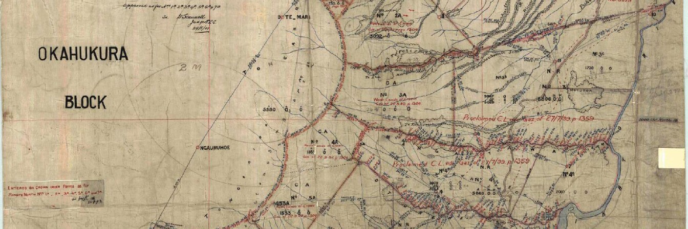
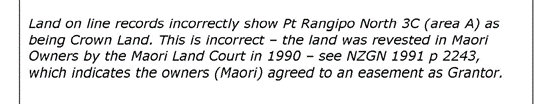
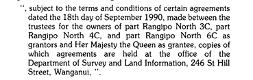
In 2013, 2 new easements were surveyed over the adjoining DOC land for access to the hydro works (survey plan SO 45009). The plan also showed the existing easement created by the 1991 Gazette notices. The surveyor indicated in his survey report that the easement land may have revested in Māori owners through the Māori Land Court in 1990. Despite this comment, land records were never altered, and everything indicates it is still held as Crown land.
Kaimanawa road SO 450095 from 2013
Tree Trunk Gorge road
In 1983 the sections of Tree Trunk Gorge access were surveyed (survey plans SO 33384, SO 33385, and 333486). This was for work associated with the Tongariro Power Scheme. NZ Gazette 1991, page 12, gazetted a right of way under the Public Works Act to the Crown for the generation of electricity. A right of way sits over the underlying land. The land under the access where it crosses private land has always remained in private ownership.
Tree Trunk Gorge road SO 33384 from 1983
Tree Trunk Gorge road SO 33385 from 1983
Tree trunk Gorge road SO 33386 from 1983
Kaimanawa road NZ Gazette 1991 page 12
An amendment to the original notice, NZ Gazette 1991, page 2243, then added the following terms and conditions to the earlier notice:
Tree Trunk Gorge road NZ Gazette 1991 page 2243
The file referenced at the bottom of the 1991 Gazette notices is not held in NZ Archives. It is unknown where this file is. It is unknown what the terms and conditions contained in the agreements between the owners and the Crown are.
In 1993 the Gazette notices were registered (Instrument B294899.1) against the land acquired for the generation of electricity but the easements acquired were not able to be registered due to an incomplete Māori Land Court action. This action appears to be about the transfer of land under some of the easements back to the former landowner. This transfer couldn’t be registered in 1993 and has not been completed since.
Tree Trunk Gorge instrument B294899.1
The private freehold land Title 494393 was issued in 2009. There are no easements or other access rights registered on this title.
Tree Trunk Gorge road Māori freehold Title 494393
A more recent survey (survey plan ML 450523) near the eastern end of the access has been prepared but not approved by LINZ. Survey plan details cannot be seen until the survey plan is approved. The purpose of this survey is unknown.
Tree Trunk Gorge access has always been a right of way over private land. The terms and conditions of the access are unknown.